


 06.37
06.37
 Unknown
map of probolinggo

Probolinggo is one part of the East Java Province which is located near
to Mount Semeru, Mount Argopuro and Tengger mountain broadly about
1696,166 Square km, precisely at 1128 51' - 1138 30 ' East Longitude and
78 40' - 88 10 ' South Latitude, stay at height 0 - 2500 m dpl with
average temperature 278 Celsius up to 308 Celsius, while its air of
south part is having low temperature. Probolinggo regency has tropical
climate and has two seasons that is dry season and the rains. Between
the seasons, there is transition season with puff wind that boisterous
enough and dry, it is known as "Angin Gending".
In the executing of the development that had oriented at the improvement of human resources through exploiting of nature source and other sources. Probolinggo regency has many kinds of tourism objects such as; Mount Bromo, Madakaripura waterfall, Giliketapang island with its marine park, Bentar beach, Ranu Segaran and warm water pool which located in Tiris beach and Jabung temple that express the past glorious. Besides that Probolinggo regency has many kinds of traditional habitually such as; Bull racing, Kuda Kencak dance, Glipang dance and Slempang dance, Pangore dance and Tenggerese traditional event. Besides its tourism objects and its culture, Probolinggo regency also yield fruits, vegetables and other plantation product that has affect the increasing earnings of area, to fulfill the development of its area for agenda of ' Area Autonomy '.
In the executing of the development that had oriented at the improvement of human resources through exploiting of nature source and other sources. Probolinggo regency has many kinds of tourism objects such as; Mount Bromo, Madakaripura waterfall, Giliketapang island with its marine park, Bentar beach, Ranu Segaran and warm water pool which located in Tiris beach and Jabung temple that express the past glorious. Besides that Probolinggo regency has many kinds of traditional habitually such as; Bull racing, Kuda Kencak dance, Glipang dance and Slempang dance, Pangore dance and Tenggerese traditional event. Besides its tourism objects and its culture, Probolinggo regency also yield fruits, vegetables and other plantation product that has affect the increasing earnings of area, to fulfill the development of its area for agenda of ' Area Autonomy '.
Object Of Tourism Probolinggo Regency
Mount Bromo
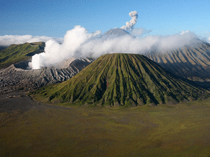
- Mount Bromo (Indonesia: Gunung Bromo), is an active Volacano and part of the Tengger massif, in East Java,Indonesia. At 2,329 metres (7,641 ft) it is not the highest peak of the massif, but is the most well known. The massif area is one of the most visited tourist attractions in East Java, Indonesia. The volcano belongs to the Bromo Tengger Semeru National Park. The name of Bromo derived from Javanese pronunciation of Brahma, the Hindu creator god.
Mount Bromo sits in the middle of a vast plain called the "Sea of Sand" (Javanese: Segara Wedi or Indonesian: Lautan Pasir), a protected nature reserve since 1919. The typical way to visit Mount Bromo is from the nearby mountain village of Cemoro Lawang. From there it is possible to walk to the volcano in about 45 minutes, but it is also possible to take an organised jeep tour, which includes a stop at the viewpoint on Mount Penanjakan (2,770 m or 9,088 ft) (Indonesian: Gunung Penanjakan). The best views from Mount Bromo to the Sand Sea below and the surrounding volcanoes are at sunrise. The viewpoint on Mount Penanjakan can also be reached on foot in about two hours. From inside the caldera, sulfur is collected by workers.


0 komentar :
Posting Komentar